Network-Based Location System
A carrier-grade network-based location platform that determines device position using cell tower triangulation, timing advance, and signal measurement — without requiring GPS or device-side software. Essential for emergency call location (E911/E112), lawful intercept compliance, and network-side location intelligence.
Pinpoint every device on your network using only cell towers, signal timing, and triangulation. No GPS required.
When Accuracy Is Mandated and Lives Depend on It
Emergency regulators demand precise caller location. Law enforcement requires lawful intercept with position data. Without network-based location, operators cannot meet these requirements.
Emergency Calls Demand Instant, Accurate Location
When someone dials emergency services, the operator needs their location immediately. Regulations like US E911 and EU E112 mandate specific accuracy levels. Without NBLS, operators face regulatory fines, legal liability, and delayed emergency response.
GPS Fails When It Is Needed Most
GPS requires clear sky view. It fails indoors, in urban canyons, in tunnels. Emergency calls often come from inside buildings. Relying solely on device GPS means your location platform is blind exactly when location matters most.
Lawful Intercept Requires Network-Side Location
Law enforcement agencies require real-time location data as part of lawful intercept warrants. This data must come from the network side — it cannot depend on the target device cooperating. NBLS provides network-side location that no device can disable or spoof.
No Device Dependency Means Universal Coverage
Network-based location works on every phone — 2G feature phones, 4G smartphones, 5G devices, IoT sensors, roaming visitors. No app to install, no setting to enable. If the device is on the network, it can be located.
How Network-Based Location Works
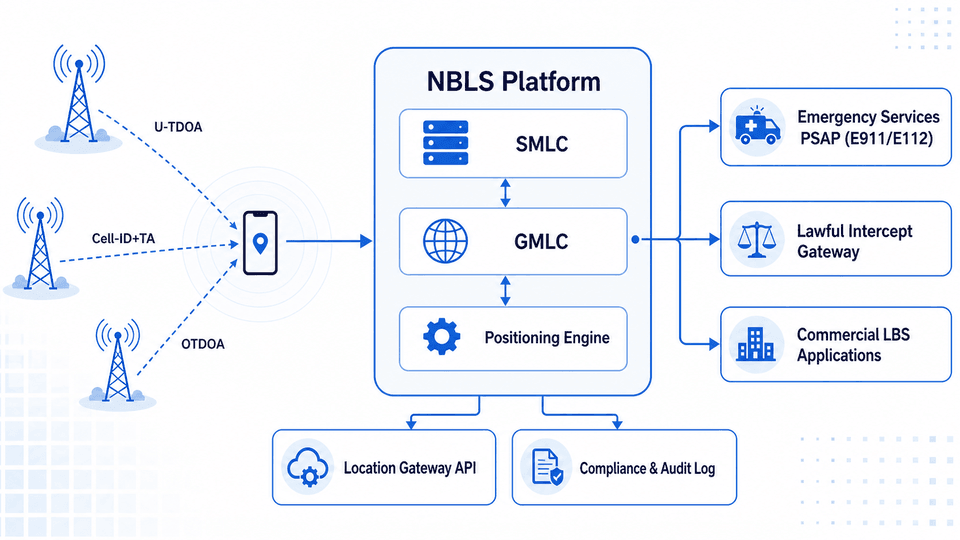
ZBensoft NBLS determines device position using only network infrastructure — cell tower measurements, signal timing, and triangulation algorithms
Cell-ID & Enhanced Cell-ID
The fastest method: the serving cell provides an immediate location estimate. Enhanced Cell-ID adds timing advance and signal strength measurements to refine accuracy from cell-radius down to 50-500m — good for commercial applications and as a rapid initial fix while more precise methods compute.
U-TDOA Triangulation
Uplink Time Difference of Arrival measures signal arrival time at multiple nearby towers. Nanosecond-level time differences allow multilateration to calculate position. Accuracy: 50-150m. Works on any device, including 2G feature phones.
OTDOA & A-GNSS
Observed Time Difference of Arrival for 4G/5G uses positioning reference signals from multiple base stations. Assisted GNSS provides satellite almanac data over the network, cutting GPS time-to-first-fix from minutes to seconds. Combined accuracy: 10-50m.
Location Gateway (GMLC/SMLC)
Standardized 3GPP interfaces for location queries. Emergency services, lawful intercept platforms, and commercial applications query device location through a single API. The gateway selects the optimal positioning method per request based on accuracy, device capability, and network conditions.
Location You Can Rely On
When regulators audit your emergency location accuracy, these are the numbers that matter.
U-TDOA triangulation provides 50-150 meter accuracy using only cell tower measurements. No GPS, no device software, no subscriber action. Meets E911 Phase II and E112 regulatory mandates.
Works on every device that registers on the network — 2G through 5G, smartphones, feature phones, IoT, roamers. Zero device dependency. If the network can see the device, NBLS can locate it.
Cell-ID provides location within seconds of query. U-TDOA computes precise fix within 5 seconds. For emergency calls, NBLS delivers location before the dispatcher answers.
NBLS requires nothing from the device — no app, no OS update, no opt-in, no GPS. Pure network-side measurement. Deploy once, locate every device immediately.
A Location Query — From Request to Response
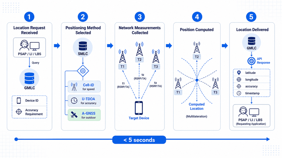
How NBLS determines position in under 5 seconds using only network infrastructure
Location Request Received
A request arrives at the GMLC — from emergency PSAP, lawful intercept platform, or commercial application. Specifies target device, required accuracy, and timeout.
Positioning Method Selected
The SMLC evaluates device capability, network topology, and accuracy needs. Emergency calls use fastest method first (Cell-ID) then refine (U-TDOA). Commercial apps select based on accuracy requirements.
Network Measurements Collected
U-TDOA: multiple towers measure uplink signal arrival time. Enhanced Cell-ID: serving cell reports timing advance and signal strength. OTDOA: device and base stations exchange positioning reference signals.
Position Computed
The positioning algorithm processes measurements. U-TDOA multilateration computes the intersection of hyperbolic curves from time-difference data. Result: geographic coordinates with confidence radius.
Location Delivered
Position returned via GMLC API — latitude, longitude, altitude, accuracy radius, timestamp. For emergency calls, pushed to PSAP before dispatcher answers. All queries logged for compliance audit.
Who Depends on Network-Based Location
Organizations for whom device location is regulatory, operational, or safety-critical
Emergency Services & PSAPs
Receive caller location automatically for every emergency call. NBLS provides network-side location that regulations mandate — dispatchers know where to send help even when the caller cannot speak.
Mobile Network Operators
Meet E911, E112, and similar mandates for emergency caller location. Deploy NBLS as a core network function integrated with MSC, MME, and AMF across 2G through 5G.
Law Enforcement Agencies
Obtain real-time device location through lawful intercept interfaces. NBLS provides network-side location via standardized LI handover — compatible with ETSI/3GPP specifications.
Regulatory Compliance Bodies
Mandate minimum location accuracy for emergency calls. NBLS provides the auditable, measurable location data that regulators require for certification and periodic accuracy audits.
Frequently Asked Questions
How does network-based location differ from GPS?
GPS requires the device to receive satellite signals with a clear sky view. NBLS uses the mobile network itself — cell towers measure signal characteristics and compute position through triangulation. NBLS works on any device, indoors, with no device-side requirements. ZBensoft NBLS combines both — using GPS/A-GNSS when available, falling back to network-based methods when GPS is unavailable or insufficient.
What accuracy is required for E911/E112 compliance?
US FCC E911 Phase II requires 100m for 67% of calls and 300m for 95%. EU E112 typically mandates 50-150m. ZBensoft NBLS with U-TDOA achieves 50-150m in typical urban and suburban deployments. Dense urban deployments with additional LMUs can achieve sub-50m accuracy.
Can NBLS locate a device with GPS turned off?
Yes — this is the fundamental value of network-based location. NBLS measures radio signals from the network side. Whether GPS is on, off, or not present is irrelevant. The network measures what every device transmits to stay connected. This is also why NBLS is essential for lawful intercept: targets cannot evade network-side location by disabling GPS.
Full-Stack Technology for Your Telecom Business
ZBensoft integrates charging, core network, and AI capabilities to help operators run efficiently and grow sustainably.
Request a Demo