Location-Based Services Platform
From emergency response to asset tracking — know where it matters, when it matters
Without Location Intelligence, Opportunities and Threats Remain Invisible
Every mobile operator, government agency, and enterprise needs location awareness. Without it, you are operating blind — unable to respond to emergencies, protect assets, or deliver context-aware services that customers now expect.
Emergency Response Delayed by Minutes That Cost Lives
When a 911/112 call comes in, every second counts. Without accurate caller location, first responders waste precious time searching — driving past the actual incident location while the clock runs out. Regulatory mandates like E911 and E112 demand precision that legacy networks cannot deliver.
High-Value Assets Vanish Without a Trace
Fleet vehicles, shipping containers, field equipment — millions of dollars in mobile assets move through your operations daily. Without real-time location tracking, theft goes undetected until it is too late, utilization stays invisible, and operational efficiency is guesswork.
Customer Experiences Lack Spatial Relevance
Modern consumers expect services that know where they are. Ride-hailing, food delivery, nearby offers, location-based authentication — these are table stakes today. Operators and enterprises without a location platform cannot participate in the location-aware economy.
Regulatory Mandates Create Compliance Exposure
Governments worldwide now require telecom operators to provide caller location for emergency services, support lawful intercept with location data, and deliver public warnings to specific geographic areas. Non-compliance means fines, license revocation, and public accountability failures.
The LBS Platform — Turn Location Data Into Business Value
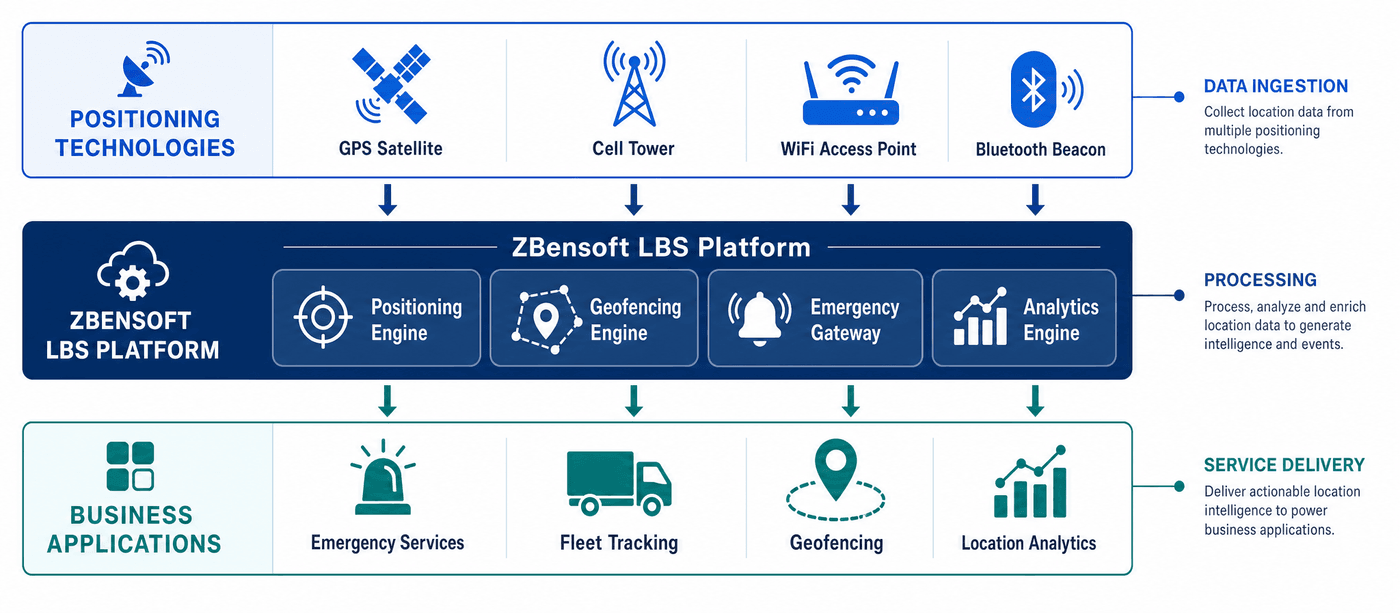
ZBensoft LBS is a carrier-grade location platform that ingests raw positioning data from any source — cell towers, GPS, WiFi, Bluetooth — and transforms it into actionable location intelligence for emergency services, enterprise applications, and government systems
Multi-Source Positioning Engine
Ingest location data from every available source — Cell-ID, enhanced Cell-ID, timing advance, GPS/AGPS, WiFi positioning, and Bluetooth beacons. The engine fuses multiple sources to deliver the best possible location accuracy for each scenario: meter-level for GPS outdoors, hundred-meter-level for network-based positioning indoors.
Geofencing & Spatial Rules Engine
Define virtual perimeters around any geographic area — a construction site, a delivery zone, a high-security facility, a disaster area. The rules engine monitors millions of devices in real time, triggering alerts and actions when devices enter, exit, or linger within geofenced zones. No polling, no latency — event-driven architecture.
Emergency Location Gateway
Purpose-built for E911, E112, and regional emergency mandates. When an emergency call is placed, the gateway retrieves the caller's location within milliseconds and routes it to the Public Safety Answering Point (PSAP) through standard protocols (MLP, HELD, RoAM). Carrier-grade reliability means every emergency call gets a location — no exceptions.
Location Analytics & Visualization
Transform raw location streams into business insights. Heat maps of subscriber density, movement pattern analysis for urban planning, dwell-time analytics for retail site selection, and trajectory reconstruction for security investigations. A built-in visualization dashboard makes spatial data accessible to business users, not just GIS specialists.
Core Capabilities That Make Location Work at Scale
Processing billions of location updates daily while maintaining sub-second latency — carrier-grade location is harder than it looks
Geofencing & Proximity Alerts
Define any number of virtual zones — circles, polygons, route corridors. Trigger real-time notifications via SMS, push, or API webhook when devices cross boundaries. Applications: fleet route compliance, child safety zones, asset theft prevention, proximity marketing, and disaster area alerts.
Asset & Fleet Tracking
Continuous real-time tracking of vehicles, equipment, shipments, and personnel. Historical trail playback, speed monitoring, geofence-based dispatch, and utilization analytics. Reduce fleet costs by 15-25% through route optimization and misuse detection.
Emergency Call Location
Fully compliant with E911 (FCC), E112 (EU), and APAC emergency location mandates. Supports network-based positioning (Cell-ID, E-Cell-ID, U-TDOA) and device-based positioning (GPS, AGPS). Integrates with any PSAP via MLP, HELD, or RoAM interfaces. Push and pull location modes for maximum compatibility.
Location Analytics Suite
Pre-built analytics dashboards for the most common location questions: Where do subscribers concentrate at different times of day? Which routes do vehicles actually take versus planned? Where are coverage gaps for location accuracy? Export data to GIS tools or BI platforms for deeper analysis.
Multi-Protocol Location Gateway
One unified gateway speaks MLP (OMA), RoAM (3GPP), HELD (IETF), and REST/JSON. External applications — PSAPs, enterprise tracking systems, government GIS platforms — connect through a single integration point. Protocol translation happens transparently inside the platform.
Measurable Impact — What Location Intelligence Delivers
When you know where your people, assets, and customers are, everything changes. These are the outcomes our customers achieve.
Who Needs Location Intelligence?
LBS is horizontal technology — it powers use cases across government, enterprise, and consumer markets
Government & Public Safety
Emergency Services (E911/E112)
Provide accurate caller location to PSAPs. Meet regulatory mandates while giving first responders the information they need to save lives.
Public Warning Systems
Enable geo-targeted emergency alerts — send warnings only to mobile devices in the affected area. Integrated with CBC/CBE for national public warning deployments.
Law Enforcement & Security
Support lawful intercept with location data. Monitor perimeter security zones. Reconstruct suspect movements from historical location trails.
Smart City & Urban Planning
Analyze population movement patterns for transit planning, event crowd management, and infrastructure investment decisions.
Enterprise & Commercial
Logistics & Fleet Management
Track every vehicle in real time. Optimize routes, monitor driver behavior, prevent fuel theft, and prove delivery SLAs with timestamped location trails.
Asset Tracking & IoT
Attach location-aware tags to containers, equipment, and high-value goods. Know where every asset is — on the warehouse floor, on a truck, or at a customer site.
Retail & Proximity Marketing
Detect when opted-in subscribers enter a store radius. Deliver personalized offers, measure foot traffic, and understand customer movement patterns inside retail spaces.
Banking & Fraud Prevention
Use location as an authentication factor. Flag transactions where the card is in one city and the phone is in another. Meet PSD2 and regional financial regulations.
Deployment Flexibility — Your Network, Your Rules
Carrier-grade means fitting into your existing infrastructure, not forcing a rewrite
On-Premise
Deploy within your own data centers for full control over data sovereignty, security, and network integration. Ideal for government and national operators.
Cloud-Native
Run on Kubernetes for elastic scale. Spin up additional location nodes during peak hours, scale down at night. CI/CD pipeline integration for continuous delivery.
Managed Service
ZBensoft operates the platform for you — monitoring, patching, upgrading, and scaling. You focus on building location-enabled services while we handle the infrastructure.
Frequently Asked Questions
What is the difference between LBS and GPS?
GPS is a satellite positioning technology — one source of location data. LBS (Location-Based Services) is a platform that ingests location from multiple sources — GPS, cell towers, WiFi, Bluetooth — and turns that raw data into business services like geofencing, emergency location routing, asset tracking, and location analytics. Think of GPS as a sensor and LBS as the brain that makes that sensor data useful for business applications.
Can LBS work indoors where GPS fails?
Yes. While GPS signals weaken indoors, ZBensoft LBS combines WiFi positioning, Bluetooth beacons, and enhanced Cell-ID to provide indoor location. Accuracy ranges from room-level (Bluetooth) to floor-level (WiFi) depending on beacon density. This is essential for applications like warehouse asset tracking, hospital equipment location, and in-store customer engagement.
How does LBS handle subscriber privacy?
ZBensoft LBS includes a comprehensive privacy framework: opt-in consent management for commercial location services, role-based access control for location queries, configurable data retention policies, and audit logging of every location lookup. For emergency calls, location is provided without consent (as permitted by law). For commercial services, subscribers must explicitly opt in and can revoke consent at any time.
What accuracy can we expect from network-based positioning?
Accuracy depends on the positioning method and network density. Basic Cell-ID: 200m-5km radius. Enhanced Cell-ID (with timing advance): 50m-500m. U-TDOA (triangulation): 50m-150m. WiFi positioning: 10m-50m indoors. GPS/AGPS: 3m-10m outdoors. The platform automatically selects the best available method for each location request based on the required accuracy and the available signal sources.
Full-Stack Technology for Your Telecom Business
ZBensoft integrates charging, core network, and AI capabilities to help operators run efficiently and grow sustainably.
Request a Demo