Geographic Information System — The Unified Spatial Data Foundation
A proprietary GIS platform serving as the unified spatial data foundation for smart cities, smart ports, smart vessels, and telecom operators — integrating multi-source geospatial data management, 2D/3D digital twin visualization, spatial analysis algorithms, and open APIs to enable location-intelligent applications across industries.
The spatial data foundation that turns maps into intelligence — powering smart cities, ports, vessels, and telecom networks
Without a Unified Spatial Platform, Location Data Sits in Silos
Every industry depends on location intelligence. But when spatial data is scattered across departments, formats, and vendors, organizations cannot connect the dots between what happens where — and why.
Spatial Data Fragmented Across Systems
Vector data in one department, raster imagery in another, IoT sensor streams in a third, BIM models with a contractor. Each dataset uses different formats, coordinate systems, and update cycles. Without a unified spatial platform, integrating these sources requires months of custom engineering — and breaks every time a source changes.
2D Maps Cannot Represent the Real World
Flat maps cannot capture building heights, underground infrastructure, or indoor spaces. When cities manage skyscrapers, subways, and utility tunnels, or ports track container stacks and crane movements, 2D visualization falls short. Decision-makers need 3D digital twins that mirror physical reality.
Spatial Analysis Requires PhD-Level Expertise
Buffer analysis, network routing, viewshed calculation, suitability modeling — powerful GIS algorithms exist, but they are locked behind specialized desktop software that requires trained GIS analysts to operate. Business users who need quick answers — "where should we build the next tower?" — cannot wait weeks for a spatial analysis report.
No Common Platform for Cross-Department Collaboration
Urban planning uses GIS for zoning. Public safety uses it for emergency response. Transportation uses it for traffic management. Each department maintains its own maps, data, and tools — with no shared spatial foundation. When a crisis hits, nobody has the complete picture.
GIS Application — The Unified Spatial Data Foundation
ZBensoft GIS Application provides the core spatial capabilities that every location-intelligent application needs — from data ingestion to visualization to spatial analysis
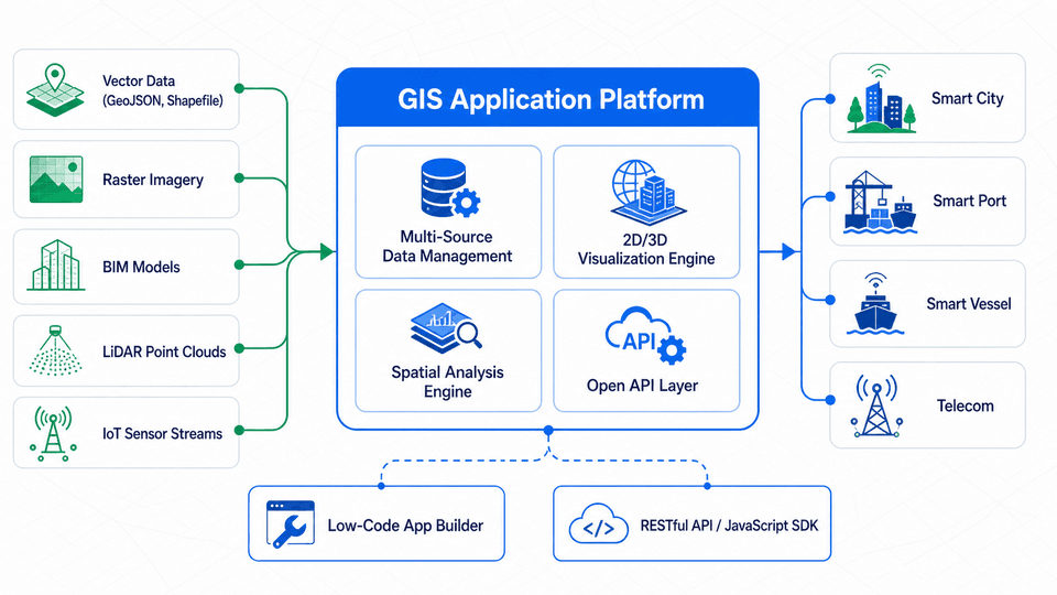
Multi-Source Spatial Data Management
Ingest and manage vector data, raster imagery, oblique photography, BIM models, LiDAR point clouds, and real-time IoT sensor streams. Built-in spatial database engine compatible with PostGIS and Oracle Spatial. Supports GeoJSON, Shapefile, KML, CityGML, and other standard formats for import and export.
2D/3D Digital Twin Visualization
Seamless switching between 2D electronic maps and 3D digital twin scenes. 2D supports tile maps, heat maps, aggregation maps, and flow maps. 3D leverages WebGL and gaming engine technology for high-precision modeling and real-time rendering of urban buildings, port facilities, and vessel equipment with dynamic lighting and weather effects.
Spatial Analysis & Algorithm Engine
Comprehensive spatial analysis operators including buffer analysis, overlay analysis, network analysis, terrain analysis, viewshed analysis, and interpolation. Rule engine enables drag-and-drop composition of complex business models such as site selection, coverage radius calculation, and optimal path routing — making spatial analysis accessible to business users, not just GIS specialists.
Open API & Low-Code App Builder
RESTful API, JavaScript SDK, and low-code application builder enable rapid integration of map display and spatial query capabilities into third-party business systems. Built-in industry component library — geofencing, trajectory replay, resource distribution maps, alert positioning — reduces industry application delivery cycles from months to weeks.
Platform Capabilities That Power Location Intelligence
ZBensoft GIS Application combines the core capabilities required to build, deploy, and scale geospatial applications across any industry.
Private Deployment & Offline Maps
Supports fully private on-premise deployment with offline map tile packages. Essential for classified government facilities, defense installations, and network-isolated environments where data sovereignty and air-gapped operation are non-negotiable requirements.
Million-Point Real-Time Rendering
High-performance rendering engine handles one million plus dynamic data points with smooth frame rates — enabling real-time monitoring of massive IoT device fleets, vehicle tracking systems, and sensor networks without performance degradation.
Multi-Map Provider Compatibility
Compatible with AutoNavi (Amap), Baidu Maps, Tianditu, OpenStreetMap, and custom map tile servers. Organizations can switch between map providers or use multiple providers simultaneously — no vendor lock-in for base map services.
Multi-Format Data Interoperability
Native support for 30+ geospatial data formats including GeoJSON, Shapefile, KML/KMZ, CityGML, GeoTIFF, LAS/LAZ (LiDAR), IFC (BIM), and 3D Tiles. Eliminates the data conversion bottleneck that delays most GIS projects.
Spatio-Temporal Analysis
Track how spatial patterns change over time. Analyze vehicle trajectories, population movement, asset utilization, and environmental changes across hours, days, or years. Time-slider visualization reveals trends invisible in static maps.
Role-Based Access & Data Security
Granular access control to spatial datasets, map layers, and analysis tools based on user roles and organizational hierarchy. Full audit logging of all data access and analysis operations. Meets requirements for government classified information management.
The GIS Platform by the Numbers
These are the technical and business metrics that define the GIS Application platform.
Real-time rendering of over one million dynamic data points with smooth interaction at 30+ FPS — supporting city-scale IoT networks, nationwide vehicle fleets, and dense sensor deployments without performance compromise.
Native ingestion and export of over 30 industry-standard geospatial formats, eliminating the data preparation bottleneck. From legacy Shapefiles to modern 3D Tiles, from drone imagery to BIM models — one platform processes them all.
One-click switching between 2D map views and immersive 3D digital twin scenes. Zoom from a continent-scale overview to a building-scale interior in seconds — with all spatial context preserved across every zoom level.
The low-code app builder and component library reduce custom GIS application development from months to weeks. Pre-built industry templates for smart city, port, and vessel accelerate deployment while allowing full customization.
Who Builds on the GIS Application Platform
From government agencies to enterprise operators — any organization that needs location intelligence as a core capability
Government & Smart City Operators
City operations centers, urban planning departments, emergency response agencies, and public utilities. GIS Application provides the unified spatial data foundation for city-level digital twins, one-map management, and cross-department situational awareness.
Port & Maritime Authorities
Port operators, terminal managers, customs agencies, and maritime safety authorities. GIS Application supports 3D digital twin modeling of port facilities, real-time vessel and container tracking, and intelligent safety monitoring.
Shipping & Fleet Management Companies
Ship owners, vessel management companies, and maritime regulatory bodies. GIS Application enables global fleet position monitoring, route optimization, equipment remote monitoring, and carbon emission compliance management.
Telecom Network Operators
Network planning, coverage optimization, asset inventory, and field operations. GIS Application integrates with OSS/BSS systems to provide spatial visualization of network infrastructure — towers, fiber routes, base stations, and service coverage.
Frequently Asked Questions
Can GIS Application be deployed in an air-gapped environment?
Yes. ZBensoft GIS Application fully supports private on-premise deployment with no external network connectivity required. Offline map tile packages can be pre-loaded for any geographic region. All spatial analysis algorithms run locally without cloud API calls. This makes the platform suitable for classified government facilities, defense installations, and critical infrastructure operators with strict data sovereignty requirements.
What 3D data formats does the digital twin engine support?
The 3D engine supports oblique photography (OSGB, 3MX), LiDAR point clouds (LAS, LAZ), BIM models (IFC, RVT via conversion), 3D Tiles (Cesium standard), and generic 3D formats (OBJ, FBX, GLTF/GLB). Models from different sources can be combined in the same scene — for example, city-scale oblique photography overlaid with detailed BIM models of individual buildings, all rendered at interactive frame rates.
How does GIS Application integrate with existing business systems?
ZBensoft GIS Application provides RESTful APIs for map embedding, spatial query, geocoding, and data visualization. A JavaScript SDK enables web application integration with a few lines of code. For enterprise integration, pre-built connectors support common databases (PostgreSQL/PostGIS, Oracle), IoT platforms (MQTT, Kafka), and business systems (CRM, ERP, OSS/BSS). The low-code app builder enables business analysts to create spatial dashboards without writing code.
Full-Stack Technology for Your Telecom Business
ZBensoft integrates charging, core network, and AI capabilities to help operators run efficiently and grow sustainably.
Request a Demo